
- Car Directions
- Write a Review
- Bookmark
- Sign in
- prev
- next
Sponsors
Review of the Route
Introduction:
The Alta Via Bepi Zac (literally "Alta Via Bepi Zac") is a very beautiful itinerary that runs along the rocky ridge from Passo Selle to Forcella Laghet on the Monzoni Group in the province of Trento. The itinerary has some aided and exposed points that require attention although large sections of the first half of the route could be considered easy. Itinerary with great historical interest for the remains of the trenches and war positions of the First World War.
Starting location:
The starting point of the itinerary is near the Passo di San Pellegrino (1907 m) in the province of Trento, on the homonymous highway linking Moena (Val di Fassa) with Falcade. If you want to take the cable car for the first part of the route, you should park near the Hotel Monzoni and take the cable car ascending towards Passo delle Selle (Directions for Google Maps available here).
If, on the other hand, you do not want to use the cable car for the climb, it may make sense to park right at the pass from which we will take the 604 path uphill, and then back. Directions for Google Maps available here.
Approach:
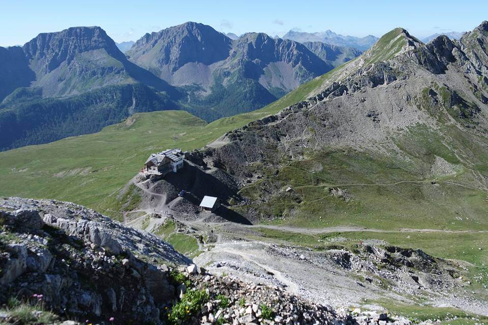
The goal of our approach to take the Alta Via Bepi Zac is to reach the hut at Passo delle Selle (2528 m). As mentioned in the paragraph above, to fill part of the 700-meter difference in level of the approach, it is possible to use the cable car that from the Pass brings us close to the Rifugio. In this case, once we reach the top station of the cable car, we will initially proceed north on path 604A up to a junction where we ignore straight the signs for Forcella Ciadin and Cima Uomo and we continue on a track on the lawn that branches off to the left and into a sloping ground in the meadows takes us to the hut (45 'from the top station of the cable car).
If we do not want to use the cable car, from the Pass - where it is clearly visible the ridge on which the alta via will develop, we take the optimally marked CAI 604 that in moderate and constant ascent among the meadows will lead us first to the Paradiso Restaurant and then to the hut from which theAlta Via Bepi Zac (1h 30 'from the San Pellegrino Pass).
Via Ferrata:
From the Passo delle Selle - the crossing point between the Alta Via Bepi Zac and the Alta Via Bruno Federspiel - we continue in a southerly direction towards the obvious ridge passing alongside old remnants of military activities and of monuments to the Great War. We continue on the CAI 637 which helps us to quickly gain altitude leaving us behind Passo Selle, the hut and the small shelter. We meet the first wire ropes in sections little landslide but not difficult. We now remain on the ridge and encounter other obvious signs of the war activities of the last century, some of which stand out as galleries.
We continue uphill to meet in a quick succession the Little Lastel (2697 m - 30 'from Passo Selle) and the Grande Lastel (2716 m - 1h from Passo Selle). In both points we have a magnificent view of the groups surrounding the Monzoni: il Sella Group, the Catinaccio, the Ombretta and Colac with the Marmolada behind and then continue on the ridge . This section is free of difficulties and the few aided sections are to infuse security into slightly exposed passes.
Once we reach the Great Lastel we begin a series of downhill and then uphill sections of the route with the goal of reaching Cima Campagnaccia. This stretch of the hike is very interesting from a historical point of view, passing alongside barricades and walkways of the Great War, sleepers sometimes exposed, footbridges and stairs that allowed to connect sides of the mountain and carvings in the rock. A couple of steps are more delicate from the point of view of hiking such as an exposed traverse, a exposed stretch on the ridge edge and a small vertical jump for reaching the summit of Cima Campagnaccia (1h 45 'from Passo Selle) after climbing a steep and detrital gully.
From Cima Campagnaccia we initially descend towards a wide detrital saddle (2680 m) where we will notice the first escape route indicated by the CAI 604A path that takes us back to the cable car station. Continuing the itinerary we go up the opposite side of the saddle in the direction of Cima Costabella which we reach after a climb on the path. Near the Cima Costabella (2762 m - 30 'from Cima Campagnaccia - 2h 15' from Passo Selle) we meet an Austrian machine gun position and a barred gallery.
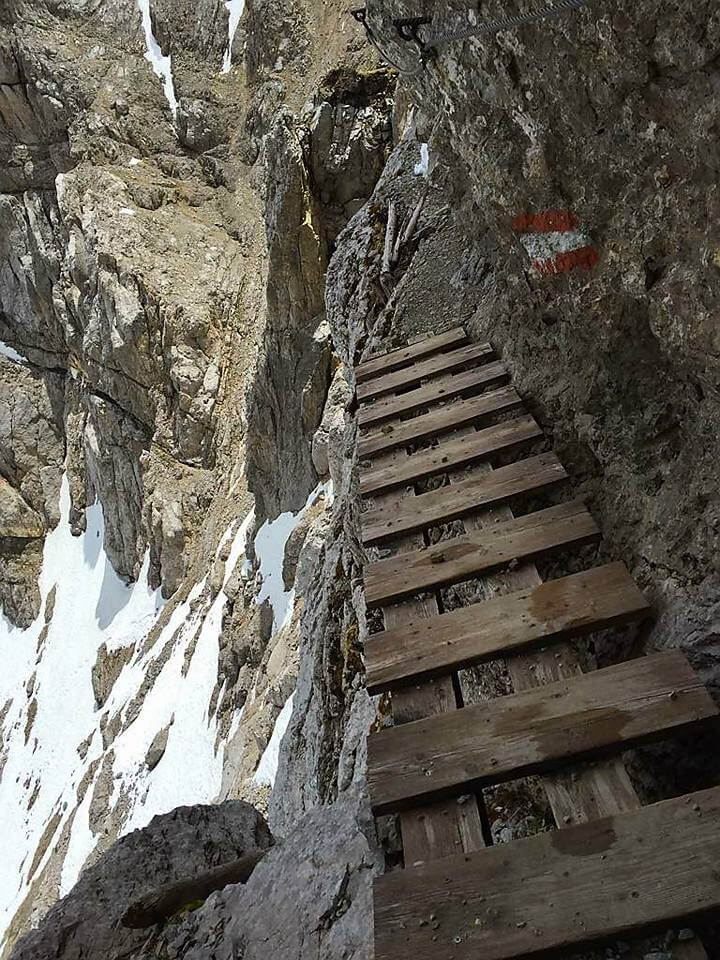
We continue from Cima Costabella in plain until we reach one rocky spur that we climb with a comfortable wooden staircase beyond which we descend a few meters assisted by a wire rope. We go down facing a first tunnel, then a rather steep descending ramp until we enter a second tunnel beyond which we lose altitude until we reach a detrital slabau where it is possible to stop the way by descending into Val San Nicolò. In this section there is one photographic display of the horrible fighting in this part of the Dolomites. In this area it is possible to take one deviation on the 637B to enter a room carved into the rock that served as lookout at the Italian lines. The climb to Sasso di Costabella (2730 m) is aided and leads us into a rocky monolith from which we get out on the north side with a brief stretch of rocks on a set of stairs of theinside of a rocky fissure. From the monolith you have points with a view both on the Sella Group on opposite side. We continue now in a downhill stretch of path reaching Forcella Ciadin saddle (2664 m - 2h 15' from the start at Passo Selle) where the first half of the Alta Via Bepi Zac ends with the option to end the itinerary and return to the starting point at the pass where we left the car.
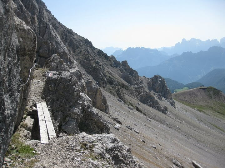
By continuing the alta via, we must keep in mind that the difficulties will increase now. We will begin by following a narrow ledge with one wooden walkway and then continue the path to a more demanding aided stretch, made of a crosspiece and a short vertical slab. We continue alternating stretches of path to some rocks until we reach an aided edge. Back up the dihedral we continue the path until we reach a fairly vertical stretch that runs along a crack. We also go up this stretch and then we find ourselves climbing up a gully. We are now on the ridge and walk along a section of unprotected path that is decidedly more adrenaline-fueled and exposed than those previously traveled. We continue among modest ups and downs, sometimes aided, until we reach the Forcella Uomo (2840 m - 3h 45' from the start on Passo Selle).
From Forcella Uomo you could take the climb after a few meters to Cima Uomo (3010 m - 2h round trip of an alpine nature without aiding wires) while if you want to finish the Alta Via Bepi Zac proceed downhill towards the Fuciade Rifugio (visible downhil). This stretch is steep and detrital with a more challenging passage than the average of the route composed of a wall of about ten meters to descend using the natural and artificial holds available. After this stretch we descend to Forcella Leghet where the Alta Via Bepi Zac finally ends (4h from Passo Selle).
Descent:
From Forcella Laghet we have a crossroads:
- descend the detrital valley to the south until you reach the Fuciade hut (1h 45' from Forcella Uomo - 5h 30' from Passo Selle) and then with the tourist path 2 reach the Passo di San Pellegrino (30' from the Rifugio Fuciade - 6h from Passo Selle), or
- descend to the right along the steep detritus valley following the track on the scree until you reach the road at the end of the valley (1h from Forcella Uomo - 4h 45' from Passo Selle). From the paved road follow the trail downhill in the direction of the visible Passo di San Pellegrino (1h from the graft onto the paved road - 5h 45' from Passo Selle).
Notes:
The itinerary of the Alta Via Bepi Zac is an itinerary of absolute interest and presents moderate difficulties in long stretches of the route with some parts more challenging and exposed, especially in the beatiful section between Forcella Ciadin and Forcella Laghet. The alta via requires a good workout being quite long and the overall height difference is greater than the absolute if you consider the various ups and downs walked along the route. A torch may be useful for some of the galleries to be crossed. The route shall be avoided in case of unstable weather being almost all on the ridge or just below. The variant ascending to Sasso di Costabella is highly recommended.
For climbing map of the area, we reccomend the map of Val di Fassa of 4Land.
Storia:
L’Alta Bepi Zac via è intitolata nel 1981 al noto alpinista fassano Bepi Pellegrin (detto Zac), grande appassionato di storia locale. Bepi Zac era anche il rifugista che lavorava al Rifugio di Passo delle Selle - dove ha inizio l'Alta Via - ora passato di mano al figlio Floriano. Nel corso del 2020 è stata oggetto di manutenzione.
Costabella era un importante caposaldo difensivo del fronte austriaco nel settore della Marmolada. L’esercito italiano aveva conquistato Sasso Costabella e Cima Uomo: sfondando al Passo delle Selle, avrebbe potuto raggiungere agevolmente la Val di Fassa scardinando la linea difensiva austro-ungarica. Nonostante aspri combattimenti, di cui si vedono chiare le testimonianze, gli italiani non conquistarono mai il Passo delle Selle ma solo Cima Costabella per poco meno di 2 settimane.
Opportunities:
The area of Monzoni and the western slope of the Marmolada is rich in aided itineraries, leaving many opportunities for via ferrata enthusiasts. A long but decidedly satisfying route is to combine the Alta Via Bepi Zac with the other alta via in the Monzoni: Bruno Federspiel. If you wish you could continue further north and combine the Ferrata Gadotti to the Sass Aut. If instead you wanted to go down on the slope of the Val San Nicolò you have some options too: you could opt for a long itinerary to the Via Ferrata Ombretta under the Marmolada or from Passo San Nicolò proceed to Via Ferrata Kaiserjager at Col Ombert. For those who are very well prepared, the most difficult route available in the San Nicolò valley is Ferrata dei Magnifici 4.
Moving instead to the Catinaccio you can walk some magnificent via ferratas too in a majestic context. Among the various, we point out the Via Ferrata Santner, the Ferrata to the Catinaccio of Antermoia, the Via Ferrata Masarè and the Via Ferrata Roda di Vael.
--
If you need to rent or buy equipment to undertake this via ferrata, we reccomend the shop "Sportler" in Str. Meisules, 276/a a Selva di Val Gardena (Bolzano), in Piazza Cesare Battisti 28 a Trento and in Via Centrale 47A a Brunico (Bolzano), sponsor of Ferrate365.
Sponsors
GPX Track
Traccia GPS per Alta via Bepi Zac. Itinerary: as per description above.
You can download: [ Traccia XML ] [KMZ Track] [Parking Point in Google Maps]
If you do not have a GPS device, follow this link to find a series of suitable devices


Print the Review?
Sponsors
Evaluation of the Itinerary
- Technical difficulties2/5
- Environmental difficulties:4/5
- Exposure:3/5
- Physical commitment:4/5
Route details
- Approach: 0:45 h
- Ferrata: 4:00 h
- Itinerary: 6:30 h
- Via Ferrata Altitude Gap: 312 m
- Route Altitude Gap: 467 m
- Max altitude: 2840 m
- Length: 12 Km
- Fassa Dolomites
- Ultima modifica relazione: 15/04/2026


Gmaps Directions

Similar Itineraries
Video Report
Do you need technical equipment?


Negozi partner di Ferrate365


Need books or Maps? We reccomend

Alpine Guides

Region and Province
marianna.rossi698
16/08/2019 at 23:36Beautiful trip for the panoramas, the route aided in itself, with ups and downs, bridges, stairways and tunnels, and of notable historical interest.
From Sass de Costabela, after having taken the variant that leads to a photographic museum set up in one of the many tunnels and huts dug into the rock (highly recommended), just before descending to Forcella Ciadin, we returned back along an easy path, and we took the path 637B along a non-trivial but fun scree towards Val San Nicolò.
Federico Bertacchini
16/08/2019 at 21:14Beautiful and historic
dario.graziano
08/08/2019 at 07:33The trenches of the First World War are really beautiful and interesting. Traveled with 2 boys aged 11 and driving
Filippo Rosi
09/03/2019 at 16:30All done except for the climb to Cima Uomo for time limits. I'll be back for that ride taking it apart. The route is beautiful, not difficult even if good weather is needed to avoid slippery stretches in non-aided areas.
Add a review


Sponsors
Weather
Sponsors
Webcams in adjacent areas
Webcam in Passo San Pellegrino - Cima Uomo
Davide Bettoni
24/08/2025 at 11:58Ferrata svolta in data 12 agosto 2025: abbiamo preso la funivia Costabella all’andata da passo San Pellegrino così da risparmiare 1h/1:30h.
In 45 minuti siamo poi giunti a rifugio Passo delle Selle, l’attacco è circato 15 minuti dopo.
Tutto il sentiero è molto ben attrezzato e suggestivo, sia per la meravigliosa vista sia per la possibilità di visitare i luoghi della grande guerra.
A un certo punto si giunge a un bivio dove se si prosegue verso destra si può visitare un memoriale, il tratto per raggiungerlo può risultare leggermente più impegnativo ma breve e la visita al museo è vivamente consigliata.
Non abbiamo proceduto per cima Uomo ma siamo scesi direttamente.
Nel nostro percorso non abbiamo trovato né particolari difficoltà tecniche né ambientali, rimane ovviamente essenziale una preparazione adeguata perché alcuni tratti risultano esposti e magari non attrezzati.
chiaradellantonio99
04/08/2025 at 11:36Ferrata percorsa in due giornate distinte. La prima parte fino a Forecella Ciadin è semplice ed è più un sentiero attrezzato che una vera e propria ferrata. Il dislivello maggiore si copre con l’avvicinamento, mentre la discesa può risultare la parte più complessa di questa prima parte.
La seconda parte è un altro paio di maniche. I tratti attrezzati sono pochi e non difficili (ad eccezione degli ultimi due che potrebbero creare dei problemi a chi non è allenato). Due elementi da non sottovalutare sono però la segnaletica, non sempre ben visibile e a volte non chiara (bivio Cima Uomo, sentieri di discesa al Passo) e le difficoltà date dai numerosi tratti da percorrere in forte esposizione su terreno franabile, anche in discesa.
Lunga ma non difficile la discesa da Forcella Laghet passando per Fuciade.
Simone Borille
11/07/2025 at 15:01Percorsa 19 giugno 2025. Non so perché è classificata difficile. io lo trovata abbastanza semplice. Fino a Passo delle Selle sentiero comodo . Da qui all’attacco sentiero ripido ma abbastanza breve. Poi si aprono scorci stupendi anche per la storicità. Unico punto impegnativo è stato il passaggio attraverso una gola ancora innevata, per il resto fattibilissima. Noi sciamo scesi per la ferrata tra la cima Campagnaccia e Costabella . credo si chiami proprio ferrata Campagnaccia ( corta, non esposta, ma con un pezzo di cavo sepolto dalla neve ). Attenzione ai molti tratti in cresta non assicurati, comunque fattibilissima e appagante. Difficolta tecniche molto basse.
andrea marinelli
11/11/2024 at 15:04L’Alta Via Bepi Zac è uno spettacolare sentiero attrezzato che scorre lungo le creste delle Cime di Costabella. Siamo a nord del Passo San Pellegrino. Bepi Pellegrin, detto Zac, era un alpinista e un tempo era il titolare del rifugio di Passo delle Selle (in tedesco: ‘Bergvagabunden Hütte’, ovvero ‘rifugio dei vagabondi della montagna’). La via offre scenari mozzafiato che vanno dalla Marmolada alle Pale di S. Martino, dal Gruppo del Sella al Sassolungo-Sassopiatto, dal Catinaccio al Latemar. La cresta del Costabella fu un importante caposaldo difensivo del fronte austroungarico durante la Grande Guerra. Lungo la Via si incontrano molte testimonianze: trincee, baraccamenti, gallerie, grotte e fortificazioni. Una caverna austriaca da visitare, era un ricovero per 12 soldati (gli interni sono originali). Si può anche visitare l’interno di un torrione roccioso adibito a piccolo museo all’aperto con una mostra fotografica di Ernst Friedrich. Dopo alcuni spettacolari passaggi (una lunga fessura nella roccia con scale) si arriva alla forcella Ciadin, dove si può terminare e rientrare al passo San Pellegrino.
Andrea Perrone
10/09/2023 at 19:21Percorsa in data 05/09/2023 con accesso dal rifugio Passo delle Selle fino all’Osservatorio italiano con discesa al Passo San Pellegrino per forcella Ciadin. Occorre prestare attenzione in alcuni tratti friabili non attrezzati, in particolare prima della Campagnaccia, che vengono per lo più percorsi in salita nel senso descritto. Per il resto la parte attrezzata è in ottimo stato e si apprezza in particolare l’attrezzatura che permette di superare in sicurezza il risalto roccioso dopo la Costabella e che sostituisce le scale in legno. In definitiva si tratta di un itinerario rimarchevole e di grande soddisfazione non solo dal punto di vista storico, ma anche da quello paesaggistico
ferretti.alex
06/09/2023 at 21:19Ferrata fatta in settembre 2023 salendo a piedi da passo S. Pellegrino, molto semplice ma relativamente lunga se abbinata con la seconda parte alpinistica passante sotto cima Uomo. Consiglio di fare tappa al mini-museo presso Sass de Costabella, molto istruttivo seppur crudo! Per i meno esperti e/o insicuri eviterei la seconda parte che da forcella del Ciadin prosegue a cima Uomo in quanto di carattere alpinistico con molti punti esposti su sentiero spesso franabile, mangiato dalle piogge e non attrezzato.
Simone Piferi OSTEOPATA
02/08/2023 at 20:13Il percorso fino al Rif delle Selle è una bel percorso dove si può evitare volentieri la cabinovia. La ferrata Bapi Zac è molto bella, non impegnativa fisicamente. Divertenti ed interessante l’esplorazione delle varie gallerie e trincee della guerra. Fino la forcella del Ciadin tutto molto fattibile. Noi abbiamo continuato per forcella dell’Uomo e forcella Laghet. Questo tratto è molto più impegnativo con tanti tratti di cengia su percorso instabile e franabile. Direi che s Eno si è stabili ed esperti di alta montagna, meglio non avventurarsi in quanto è un percorso in costante cambiamento poiché può franare. Ci sono altri piccoli tratti attrezzati con corda e staffe, molto carini ma non te lo aspetti e già ci si è tolti tutto, cmq fattibili.da forcella Laghet la discesa è su un ammasso di massi totalmente instabili anche i più grossi, quindi molta attenzione passata la prima parte della discesa risulta molto facile il rientro al passo s. Pellegrino. Occhio arrivati alla forcella dell’Uomo il sentiero scende, ad un certo punto si biforca con dei segni che salgono e portano a cima uomo, ma se si vuole arrivare a forcella Laghet, proseguire sui segni che portano in basso e poi risaliranno su un canalino attrezzato.
vnz75
25/09/2021 at 20:48L’ho fatta ben 3 volte e non smette mai di appassionarmi,l’ho fatta per la prima volta da piccolo 33 anni fa ed ora che ne ho 46 la rifarei per la quarta !
Carlo Cella
05/10/2021 at 18:52è quindi nuovamente agibile dopo i lavori di ripristino e manutenzione ?